We’ve been wanting to bring you some new features for quite some time, but circumstances just haven’t allowed.
Happily, that changes today.
Working with Island-based Open University academic and Open Knowledge data storyteller, Tony Hirst, we plan to bring OnTheWight readers new features that we hope you’ll find not only interesting and engaging, but that are useful to you as well.
First up: A map of IW Planning applications
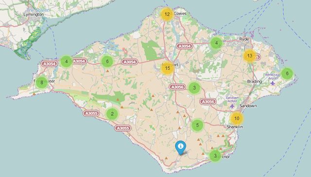
First up we have a map of all of the current planning applications on the Isle of Wight (as at today, 3rd June 2015).
Many have told us that just reading the list of text, as this is now delivered, can be quite a challenging, causing them to miss planning applications that they would have been interested to find out about.
We think maps are much easier to understand. They immediately give the viewer an understanding of where the proposed plans are to take place.
Let us know what you think
Hopefully this is just the first stage – both with the planning application data and other data that we can launch on maps.
We’re feeling our way with this, so this is your chance to let us know what you think of this first-cut, what you’d like to see added or taken away and what future ideas you’d like us to explore.
Pop over to the page
Please pop over to our trial Isle of Wight planning applications : Mapped page and let us know there what you think.