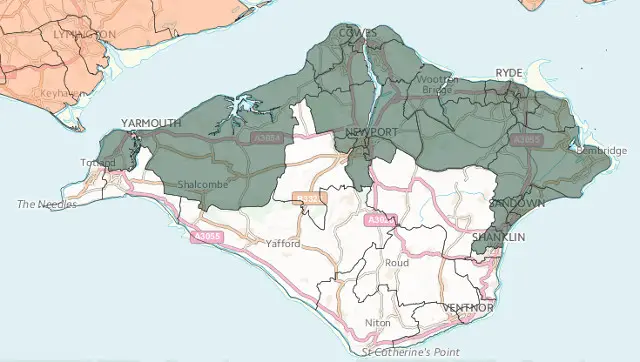
Readers may remember the news coming out of the MP’s office and Isle of Wight council before Christmas when it was announced the Isle of Wight had been included in the draft map for Assisted Area Status (AAS).
Many councillors, former-councillors and officers have been fighting to have the Isle of Wight recognised for AAS status for many years. The draft map (see above) has now been made public under the consultation which runs until Friday 7 February 2014.
Needs correct classification
Ventnor town councillor, Harry Rees, a member of IWALC who also sits on the Overview and Scrutiny Committee, is an expert on the subject. He explained to OnTheWight that the Island is currently classified ‘Criteria 1’ which is the same classification as landlocked wards.
According to Harry, the Island should be classed as ‘Criteria 3’, a classification that would bring far more opportunities to the Island.
Harry told OnTheWight,
“We welcome the Isle of Wight being identified, but ask them to reconsider the classification they have put the Island under, as per the European guidelines on State Aid.
Only part of the Island on map
As you can see from the draft map, several wards on the Island have not been included in the draft map. The dark green areas on the map above show those that have been included.
We asked the Isle of Wight council about this. They say all wards on the Isle of Wight were included in the submission sent to the government and OnTheWight was advised to contact the Department for Business, Innovation and Skills to find out why they’d not included all wards.
We’re in touch with the senior civil servant over the matter and hope to have a response in due course.
Economic growth
Harry tells OnTheWight this is because of the ‘Criteria 1’ status being applied. Under this classification, issues such as social deprivation (which the South of the Island has several pockets of) are not taken into consideration, instead it focuses on economic growth.
The subject of the classification is something Harry wrote about through OnTheWight back in July 2013.
We’ll let you know once we hear more.
Image: © Crown Copyright 2014 Ordnance Survey


