We regularly receive Yellow (Be Aware) weather warnings from the Met Office, but can’t remember the last time we saw an Amber (Be Prepared) severe weather warning.
It probably won’t be hard to guess that the Amber warning is for strong winds. This warning is valid until 3pm today and reads
Winds are expected to gust to around 70 mph over coasts, and 50-60 mph inland, whilst rain will be heavy at times. The public should be prepared for the risk of disruption to transport and power due to fallen trees. Additionally, large waves bring the risk of flooding in some coastal areas.
It’s accompanied by a Yellow warning of wind and rain until 10pm which reads,
Strong winds will bring inland gusts of around 50 mph, locally 60 mph, perhaps 70 mph on exposed coasts. There is the risk of some disruption, for example due to fallen trees.
A gradual change to more showery conditions is but still with some longer spells of rain, which could bring a further 20 to 30 mm over the hills in Wales but with 10-15 mm being a more general figure.
The public should be aware of the risk of disruption from either the wind or rain elements in this warning. Additionally, large waves mean a further risk of flooding in some coastal areas.
Very wet all week
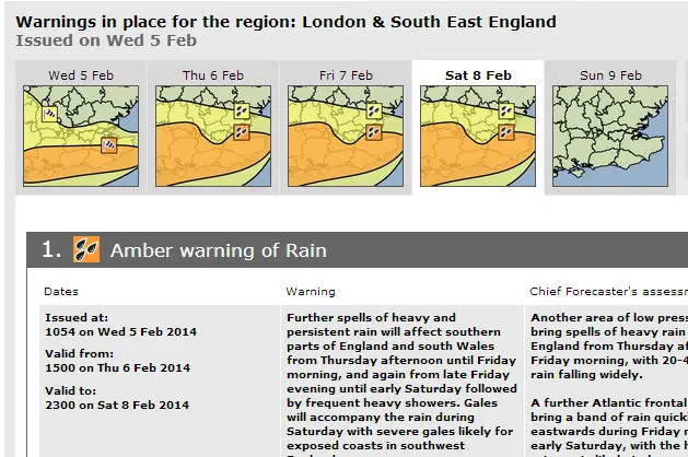
We then have an Amber warning of rain from 3pm today valid until 23.00 on Saturday,
Further spells of heavy and persistent rain will affect southern parts of England and south Wales from Thursday afternoon until Friday morning, and again from late Friday evening until early Saturday followed by frequent heavy showers. Gales will accompany the rain during Saturday with severe gales likely for exposed coasts in southwest England.
The public should be prepared for disruption due to flooding.