As reported earlier in the week, the Met Office predict very strong winds and heavy rain over the next day or two.
Their latest updates, valid from 8pm tonight (Friday) to 6am on Saturday read,
Following the heavy rain that occurred on Thursday night another band of rain, heavy at times, accompanied by coastal gales will affect southwest England during Friday evening, moving quickly east across other southern areas early on Saturday. The rain will clear the extreme southeast of England on Saturday morning, to be followed by frequent heavy and squally showers.
The public should be prepared for disruption due to flooding.
This is an update to the warning first issued on Wednesday. The end time of the warning has been brought forward since the heaviest of the rain is expected to clear though on Saturday morning. A yellow warning will remain in force through Saturday across the south to cater for further heavy showers.
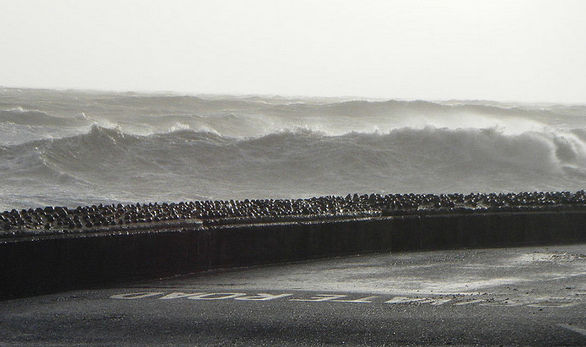
There is also an Amber warning for wind for the Isle of Wight valid from 8pm tonight (Friday) until 6am on Sunday 9th February. It reads,
Southerly gales will affect south facing coasts of southwest England and south and west Wales during Friday evening, moving east along English Channel coasts overnight into Saturday.
After a short lull, winds will increase from the southwest during the course of Saturday with severe gales affecting coastal districts, bringing gusts of 60-70 mph and isolated 80 mph at the most exposed locations within the Amber warning area. Large waves are also expected to affect southwest facing coasts. Further inland, gusts of 50-60 mph are likely.
The public should be prepared for disruption to transport and locally to power supplies, particularly when combined with the impacts of heavy rainfall (see heavy rain warnings).
This warning has been updated to extend it into the first part of Sunday and to include western Wales in the yellow area.
Image: © Used with permission of Marcia