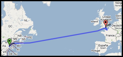
In a moment of boredom (why else would you do it) a couple of weeks back, forum regular, Farmersboy typed into Google Maps a request for directions from New York City to Ventnor, Isle of Wight.
All looks pretty straightforward as you read through the directions ….

1. Head southeast on Chambers St toward Broadway 0.2 mi
2. Turn right at Centre St 0.1 mi
3. Slight left at Park Row 210 ft
4. Sharp left at Frankfort St 0.3 mi
5. Turn left at Pearl St 56 ft
6. Turn right onto the F.D.R. Dr N ramp
But then it reaches the US coast ….. directions as follows!
22. Turn right at Central St 0.1 mi
23. Turn right at Long Wharf 0.1 mi
24. Swim across the Atlantic Ocean 3,462 mi 29 days
25. Sharp left at Portsmouth – Le Havre 111 mi 5 hours 57 mins
26. Turn right at Wharf Rd 0.3 mi 1 min
27. Turn right to stay on Wharf Rd 292 ft
28. Turn left to stay on Wharf Rd 56 ft
29. At Rudmore Roundabout, take the 4th exit onto A3/Mile End Rd heading to Central Southsea/N End 0.4 m
If you just speed read the above and missed direction number 24, it said SWIM ACROSS THE ATLANTIC OCEAN – only 3,462 miles and an estimated 29 days. I think that it might be better to save up the fare.
However, what’s even weirder is that they get you to swim to Portsmouth rather than just straight to Ventnor! [image and maps all courtesy of Google Maps] [Thanks to Farmersboy, who I’ve been told is my personal rottweiler, although he insists he is just a poodle]


