If you’ve been wondering why there have been so many cables stretched across the Island road network over the last few weeks, News OnTheWight has the answer.
We put a series of questions to the Isle of Wight council (IWC) to find out more about the traffic survey devices.
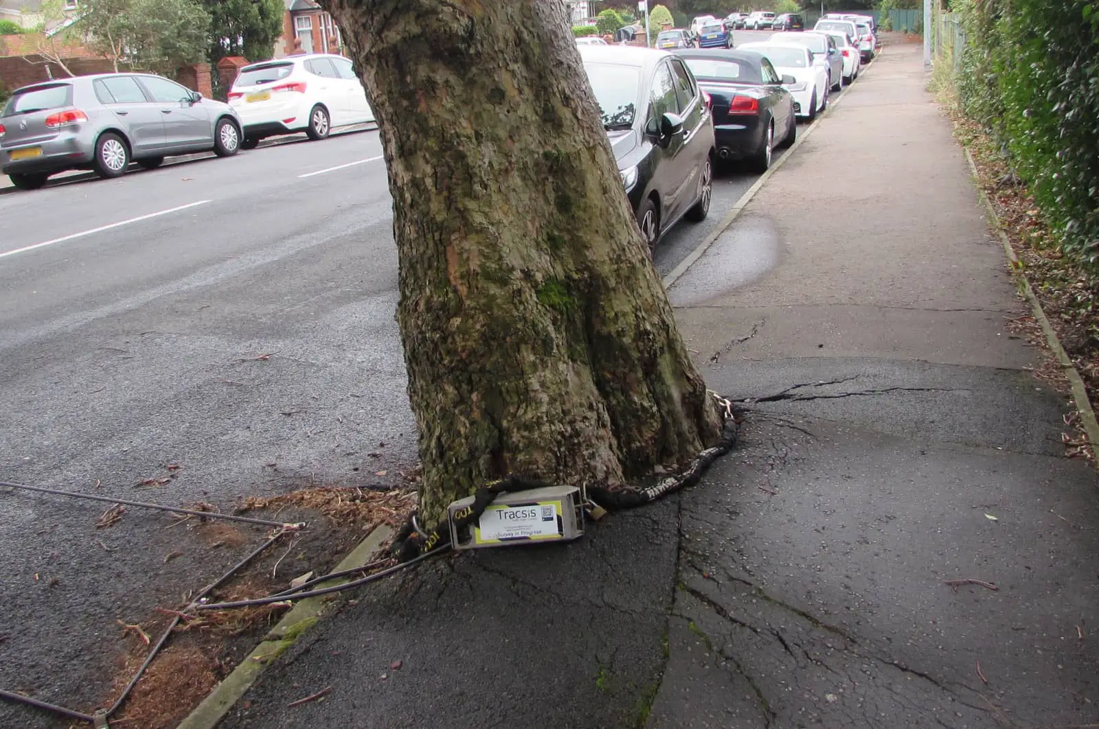
There have been a total of 217 of these devices installed across the Isle of Wight, as part of survey being carried out by the Isle of Wight council.
What data they’ve been gathering and why
They’ve been gathering data on the speed, volume and class of vehicles using the Island highways network.
The devices were installed to collect at least seven days of data with the primary purpose being to inform the council’s Island-wide speed limit review.
A report setting out the findings of the exercise will be made public by April 2023.
Locations
The speed, volume and class of vehicles were monitored for at least seven days at the following locations – as provided by IWC.
- Alum Bay New Rd, south of Cliff Rd
- Alum Bay New Rd, north of Cliff Rd
- Alum Bay Old Rd, east of Weston Ln
- Church Hill, south of Eden Rd
- Weston Ln, south of Hurst Hill
- Cliff Rd, south of Greenways
- Court Rd, north of Summers Ct
- Colwell Chine Rd, south of Chine Cl
- Colwell Rd, north of Madeira Ln
- Colwell Ln, east of Colwell Rd
- Heathfield Rd, north of The Sheilings
- Norton Grn, south Alderney Ter
- High St, north of The Old Smithy
- Silcombe Ln, west of Cooper Cl
- Avenue Rd, west of High Street
- School Green Rd, east of Parkers Hill
- Camp Rd, east of Queen’s Rd
- Victoria Rd, north of Easton Ln
- Regina Rd, east of Parkway
- Military Road A3055, west of Compton Farm
- Wilmingham Lane, south of Main Rd
- Westhill Ln, north of Graeme Rd
- Thorley Rd, south of A3054
- Main Road, east of Holmsfield Ave
- Bouldnor Rd, west of The Avenue
- Broad Lane, north of Broad Lane
- Wellow Top Rd, west of Station Rd
- A3054 east of Gas Works Lane
- The Middle Rd, west of Brook Rd
- Brook Village Rd, north of Brook Farm Cl
- B3399 East of Hulverstone Ln
- Newport Rd/The Middle Rd
- Quarry Lane, west of Elm Ln
- Warlands Ln, west of Station Rd
- Porchfield Rd, east of Porchfield Rd
- Porchfiled Rd, south of Town Ln
- Rew Street, north of Westview Rd
- March Rd, east of Rew St
- Lower Church Rd, west of Bay View Rd
- Solent View Rd, east of Albert Rd
- Worsley Rd, north of The Avenue
- Tuttons Hill, west of Baring Rd
- Cockleton Lane, north of Place Rd
- Prince’s Esplanade, north of Woodvale Rd
- Woodvale Rd, south of Gurnard Heights
- Baring Rd, north of Debourne Manor Dr
- Egypt Hill, north of Marine Vw Cl
- Three Gates Rd, north of Rogerson Cl
- Mill Hill Rd, north of Stephenson Rd
- Victoria Rd, north of St Mary’s Rd
- Crossfield Ave, north of Guppy Cl
- Crossfield Ave, south of Mountbatten Ave
- Ward Ave, north of Crossfield Ave
- Queen’s Rd, east of Stanhope Dr
- B3325 Terminus Rd south of Park Ct
- Medina Rd, north of Bridge Rd
- Pallance Lane, west of Wyatts Lane
- Venner Ave, south of Wroxall Cl
- Uplands Rd, east of Greenways
- Beatrice Ave, north of Meadow Rd
- Victoria Grove, east of Mayfield Rd
- Clarence Rd, north of Osborne Rd
- Newport Rd, south of Stephenson Rd
- Adelaide Grove, north of Yarborough Rd
- York Ave, south of Kent Ave
- Esplanade, south of Cambridge Rd
- Hefford Rd, south of Hendy Rd
- Old Rd, north of Osborne Heights
- Alverstone Rd, north of Whippingham Rd
- Dodnor Lane, south of Dodnor Mews
- Forest Rd, east of Gunville Rd
- Gunville Rd, north of The Hollows
- Castle Road
- Carisbrooke Road
- Fairlee Road A3054
- Cross Lane
- Furrlongs
- N Fairlee Road
- Racecourse A3054
- Whiterails Road
- Briddlesford Road
- E Cowes Road
- St Georges Lane
- Blackwater Road
- Betty Haunt Lane
- Calbourne Road
- Fieldfare Road
- Hinton Rd, north of Marlborough Rd
- Nelson Rd, north of Winston Rd
- St John’s Rd, south of St Johns Cl
- Mayfield Dr, south of Bellecourt Dr
- Pyle St, west of St James’ St
- New Rd, north of Coleman’s Lane
- Locks Green Rd, south of Main Rd
- Main Rd, north of New Rd
- Main Rd, south of Corf Rd
- Palmers Rd, north of Beechcroft Dr
- Church Rd, south of Church Cl
- Rectory Dr, west of Bridgway
- Binstead Hill, east of Quarry Stone Cl
- Binstead Lodge Rd, south of Golden Grvs
- Hillrise Ave, east of Dame Anthonys Cl
- Mayfield Rd, south of St Vincent’s Rd
- Pellhurst Rd, north of Ratcliffe Ave
- Spencer Rd, west of Westfield Park
- West St, south of Garfield Rd
- Esplanade, west of Quay Rd
- George St, south of Castle St
- Melville St, west of Nelson St
- Melville St, west of Trinity St
- St John’s Rd, west of Abingdon Rd
- Park Rd, west of Dover St
- Monkton St, south of Wood St
- Marlborough Rd, south of Salisbury Rd
- Upton Rd, north of Carters Rd
- Appley Road, west of Grasmere Ave
- Smallbrook Lane, west of Great Preston Rd
- Brading Rd, south of Cothey Way
- Bullen Rd, west of Cothey Way
- Newnham Lane
- Puckpool Hill, west of Puckpool Cl
- Nettlestone Hill, south of Pondwell Hill
- Seaview Lane, south of Old Seaview Lane
- Bluett Ave, east of Salterns Rd
- Fairy Rd, east of Salterns Rd
- Eddington Rd, north of Attrill’s Lane
- Upper Green Rd, west of Mill Rd
- Carpenters Rd, east of Rowborough Lane
- Station Rd, south of Downs View Rd
- Embankment Rd, east of Latimer Rd
- High St, south of Dennett Rd
- Steyne Rd, south of Preston Rd
- Swaines Rd, south of The Orchard
- Walls Rd, north of Crossway
- Howgate Rd, south of Brook Furlong
- Yaverland Rd, south of Sandown Rd
- Marshcombe Shute, east of Morton Rd
- Culver Parade, north of Fort Street
- Culver Down, Rd east of Sandown Rd
- Sandown Rd, north of Culver Down Rd
- Sandown Rd, west of Hillway Rd
- Brading Down Rd, west of Bullys Hill
- Upper Adgestone Rd, north or Upper Rd
- Lower Rd, North of longwood Ln
- Palmers Ln, west of skinners Ln
- Princelett Shute, south of Winford Rd
- Newport Rd, North of Ventnor Rd
- Forest Rd, north of forest way
- Sandown Rd, North of littlestairs Rd
- Apse Manor Rd, West of Shaklin Rd
- Green Ln, North of witbank Gardens
- Shanklin Rd, north of Upper Hyde Ln
- St johns Rd, north of Worsley Dr
- Carter Ave, north of Josephs Way
- Esplanade, north of Lift Rd
- Queens Rd, south of Clarendon Rd
- High St, north of Western Rd
- Brook Rd, north of Garfield Rd
- Luccombe Rd, north of priory Rd
- Bonchurch Rd
- Spring Hill, east of St Boniface Rd
- Mitchell Ave, north of Altofts gardens
- Park Avenue, north of belgrave Rd
- High St, north of market St
- Albert St, west of Victoria St
- Undercliff Dr, north of love lane
- Whitwell Rd, north of Foxhills
- Whitwell Rd, south of Week Ln
- St Catherine’s Rd, north of Puckaster Ln
- Barrack Shute, north of Glen approach
- Chatfield Rd, north of Kingates Ln
- Blackgang Rd south of Church St
- Newport Rd, north of Crocker Ln
- Newport Rd, north of Kingates Ln
- Blythe Shute, north of church pl
- Church Pl, west of Military road
- Military Rd, north of Southdown
- Atherfield Rd, north of Southdown
- Appleford Rd, north of Appleford Ln
- B3399 north of Short Ln
- Chine Ln, east of Thorncross
- Beacon Alley, east of Roud Rd
- New Rd, north of Mill Ln
- Military Rd, A3055 North of grange Farm
- Merstone Ln, north of Newlands
- Main Rd, Hillcrest Rd
- Main Rd, north of Pagham Ln
- Knighton Shute, south of the downs Rd
- A3056 North of Merstone Ln
- A3056 south of Downend Rd
- Combley Rd, south of public Bridleway N17
- Dodpits Ln, north of Eades Farm
- Wilmingham Ln, west of The middle Rd
- Newport Rd, north of Chawton Ln
- St Georges Way, north of Godric Rd
- Redhill Ln, East of Shanklin Rd
- Calbourne Rd, north of Rowridge Ln
- Lushington Hill, north of Park Rd
- Bowcombe Rd
- Main Rd, south of New Barn Lane
- Newport Rd, north of Worsley Rd
- Whitwell Rd, south of Merry Lane
- Niton Rd, north of Roud Rd
- Bullen Rd, north of Gregory Ave
- B3399 south of Corve Hill
- Beaper Shute, south of Harding Shute
- Gatehouse Rd, north of Highfields
- Avenue Rd, north of Fort Mews
- Broadway, south of Grove Rd
- St John’s Rd, south of Victoria Rd
- Golf Links Rd, north of The Fairway
- A3020 east of St John’s Rd
- B3327 south of Manor Rd
- Military Rd, north of Brook Village Rd
- Military Rd, east of Ridget Lane
- Arctic Rd, south of South Rd
- Ashey Rd, south of E Ashey Lane
Image: For illustration purposes only – survey equipment by Jaggery under CC BY 2.0