There appears to be no let up in the heavy rain battering the Isle of Wight. The Met Office have issued ‘Be alert’ yellow weather warnings for heavy rain for Monday, Wednesday an Thursday this week.
Valid from midnight (Sunday) until 6pm Monday, the first warning reads:
After a wet week, further heavy and at times thundery showers, are expected on Monday.
The most frequent and prolonged of which are most likely during the morning.
Many parts of the warning area will see 10 to 20 mm whilst the wettest spots, most likely near to English Channel coasts, could see 30 to 35 mm.
What to expect
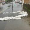
- There is a small chance that homes and businesses could be flooded, causing damage to some buildings
- Where flooding occurs, there is a slight chance of delays or cancellations to train and bus services
- Spray and flooding could lead to difficult driving conditions and some road closures
- There is a slight chance of power cuts and loss of other services to some homes and businesses
- There is a small chance that some communities will become cut off by flooded roads
You can follow the weather warning by visiting the Met Office website.
Wednesday
On Wednesday the ‘Be alert’ yellow weather warning for heavy rain is from 6pm to midnight. It reads:
Periods of heavy rain or showers are likely to affect much of the UK from late Wednesday through Thursday.
The highest rainfall amounts are likely in southern and western areas where a further 20 to 25mm is possible quite widely, and especially over high ground, where 40 to 60mm could fall in this period.
Given this amount of rainfall, and the current saturated conditions – further impacts are possible.
You can follow the weather warning by visiting the Met Office website.
Thursday
On Thursday, there are two weather warnings, one for wind and one for heavy rain.
The wind warning runs from just after midnight on Wednesday to 6pm on Thursday. It reads:
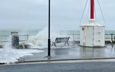
Storm Ciaran is likely to bring a spell of very strong winds to southern parts of the UK, particularly during Thursday.
Winds are likely to gust to 80mph along the south coast, with a very low risk of gusts in exposure to 90mph, and winds could gust up to 50 or 60mph inland from the early hours.
The strongest winds will begin to ease later in the day from the southwest.
The rain warning is the same as the day before, but runs from 6pm to midnight.
You can follow the warning on the Met Office website.