It’s nearly ten years(!) since OnTheWight first experimented with bringing new ways for Islanders to find out information about Isle of Wight planning applications, with the pioneering work done by/with Tony Hirst.
Back then, the challenge we found was keeping it working. Sadly, continuing it wasn’t practical as keeping the programme code up to date when any and every little alteration to the data occurred, as it broke it.
Tick followed Tock and here we are, nearly a decade later, with a new solution, where we’ve engaged some of the skills of AI this time and hope this approach will be more resilient.
The results are below, but in the future, they’ll be in their own article.
Layout / features / functions
At the top we have a list of each of the week’s new planning applications.
You’ll see that you can re-order each of the columns just by clicking on the header – useful for some like Town, Parish – but less so for others like Proposal.
There’s also a search feature, top right of the table, where you’ll be able to search for any word that might appear.
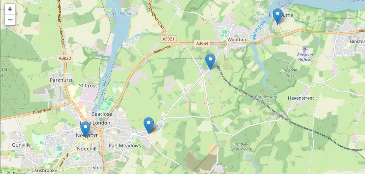
Map
Looking at a table of data is all very well, but we wanted to take it a bit further.
We’ve used the data, and through a bit of mild wizardry, we’ve created a map, as these can often be much easier for us simple humans to understand where the planning applications are located.
Clicking on the pins will show you the location of the application and its IWC planning reference number, so you can match the two up.
Thank you
Thanks to the Isle of Wight council’s planning and comms department for working with OnTheWight – and Tony Hirst for working on the original.
Let us know what you think
Despite us using tech, the process still requires time for us to prepare. The intention is to bring you this on a weekly basis, but that may slip, depending on other demands on our time.
It’d be really helpful to understand from you, dear reader, if you find it of use.
What do you think? Do you like it?
Last week’s data as an example
Copy the application number and search the council’s planning register to see the application
| Application No | Parish(es) | Ward(s) | Location | Proposal |
|---|---|---|---|---|
| 24/01378/FUL | Cowes | Cowes North | Cowes Methodist Church Birmingham Road Cowes Isle Of Wight PO31 7BH | Change of Use to Class E(b) together with associated external and internal alterations and installation of plant and extraction equipment |
| 24/01427/FUL | Cowes | Cowes North | Hamlet Court 6 Queens Road Cowes Isle Of Wight PO31 8BQ | Demolition of building; Proposed construction of two detached dwellings with parking |
| 24/01421/HOU | Fishbourne | Binstead And Fishbourne | 41 Fishbourne Lane Wootton Ryde Isle Of Wight PO33 4EX | Alterations to widen vehicular access and form parking area |
| 24/01415/FUL | Freshwater | Freshwater South | Big Blue Afton Down Freshwater Isle Of Wight PO40 9TY | Replacement dwelling (revised scheme) |
| 24/01425/FUL | Freshwater | Freshwater South | Vectis Electrical Avenue Road Freshwater Isle Of Wight PO40 9UU | Proposed Change of Use from ancillary storage to a 1 bedroom residential flat (ground floor) Dwellinghouses C3(a) |
| 24/01426/CLEUD | Freshwater | Freshwater South | Vectis Electrical Avenue Road Freshwater Isle Of Wight PO40 9UU | Lawful Development Certificate for the continued use of first floor as a residential dwellinghouse |
| 24/01442/FUL | Nettlestone And Seaview | Nettlestone And Seaview | Oristano And Rothesay Ryde Road Seaview Isle Of Wight PO34 5AD | Removal of chimney; Proposed replacement raised roof to include side dormer windows |
| 24/01446/RVC | Nettlestone And Seaview | Nettlestone And Seaview | Land To South East Of Ingle Dell Esplanade Seaview Isle Of Wight | Variation of condition 2 on 23/00113/FUL to allow alterations to the approved design |
| 24/01417/FUL | Newchurch | Newchurch Havenstreet And Ashey | Little Orchard Newport Road Apse Heath Sandown Isle Of Wight PO36 0LS | Proposed alterations and change of use of garage/workshop to form holiday unit |
| 21/02423/OUT | Newport & Carisbrooke | Fairlee And Whippingham | Land At Landscape Lane Newport Isle Of Wight | Outline for 12 houses and formation of vehicular and pedestrian access and provision of pedestrian crossing on Staplers Road (approval of access, layout and scale sought) (revised and additional plans) (revised description) (readvertised application) |
| 21/02423/OUT | Newport & Carisbrooke | Fairlee And Whippingham | Land At Landscape Lane Newport Isle Of Wight | Outline for 12 houses and formation of vehicular and pedestrian access and provision of pedestrian crossing on Staplers Road (approval of access, layout and scale sought) (revised and additional plans) (revised description) (readvertised application). |
| 24/01399/FUL | Newport & Carisbrooke Community Council | Newport Central | 51 High Street Newport Isle Of Wight PO30 1SB | Proposed internal and external alterations and change of use of second floor level from ancillary retail to two self-contained residential units, with associated outdoor amenity space to include external area for plant associated with retail use at ground floor level |
| 24/01448/HOU | Northwood | Cowes South And Northwood | 123 Wyatts Lane Northwood Cowes Isle Of Wight PO31 8PU | Proposed demolition of existing conservatory; proposed single storey rear extension and internal alterations |
| 24/01372/HOU | Ryde | Ryde North West | 20 Dover Street Ryde Isle Of Wight PO33 2AQ | Partial demolition of front boundary wall; Proposed car port and formation of vehicular access |
| 24/01416/FUL | Ryde | Ryde North West | 11 Wellington Court Augusta Road Ryde Isle Of Wight PO33 3AT | Replacement of 6 dormer windows |
| 24/01313/FUL | Sandown | Sandown South | 11 High Street Sandown Isle Of Wight PO36 8DA | Proposed alterations and conversion of ground floor and new first floor extension to form assisted accommodation for adults; provision of roof terrace |
| 24/01434/3MAPA | Shanklin | Shanklin South | 17 High Street Shanklin Isle Of Wight PO37 6JZ | Prior approval for change of use of first and second floors from storage to create two flats |
| 24/01166/HOU | Totland | Totland And Colwell | Former Country Garden Hotel Church Hill Totland Totland Bay Isle Of Wight PO39 0ET | Demolition of south garage wing, north-west single storey wing, eastern two storey wing & single storey northern structures; Proposed rear 'extension', orangery & greenhouse; Detached gym building and detached garage building |
| 24/01302/LBC | Ventnor | Wroxall Lowtherville And Bonchurch | St Michaels Cliff The Pitts Ventnor Isle Of Wight PO38 1NT | Listed Building Consent for proposed replacement of 4 windows on western elevation (to include slim doubled glazed units) |
| 24/01393/RVC | Wootton Bridge | Wootton | 115 Station Road Wootton Ryde Isle Of Wight PO33 4RG | Variation of conditions 2 and 9 on P/00962/18 to allow alterations to layout and realignment of footpath |
Map
(Zoom in and out to see details. Clicking on the pins will tell you the address and the reference number if you want to look up the detail)