The council share this latest news. Ed
It’s that time of year again as the Island prepares to welcome thousands to the Isle of Wight Festival.
The Isle of Wight Council, Island Roads and Hampshire Constabulary are once again working closely with the organisers of this year’s festival to ensure traffic flows smoothly and disruption is kept to a minimum for the world-famous event.
The council and partner agencies have approved the traffic management plans submitted by the event organisers, covering areas such as event car parks, separating Red Funnel and Wightlink traffic and measures to ensure close co-ordination between partners.
Keeping disruption to a minimum
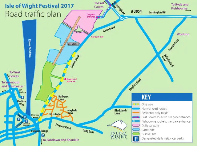
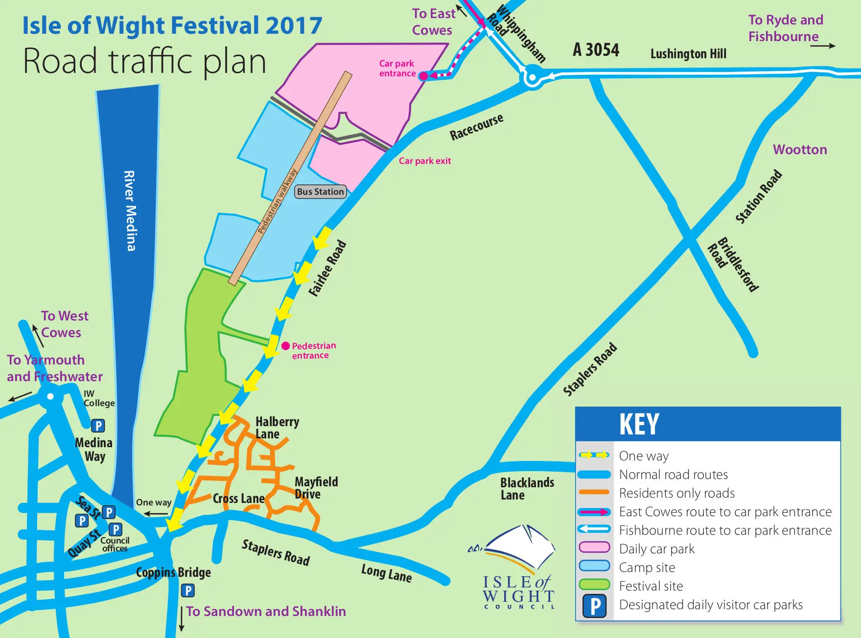
The plan is designed to ensure disruption to local traffic is kept to a minimum, although some delays are inevitable with the increased levels of traffic on the roads.
The main route for festival traffic from the Red Funnel terminal at East Cowes will be up York Avenue and along Whippingham Road where it will turn right onto East Cowes Road and into the festival car park.
Festival-bound vehicles travelling from the Wightlink terminal at Fishbourne will be directed to the right on to Kite Hill, through Wootton, down Lushington Hill and right at the Racecourse roundabout and then left onto East Cowes Road and into the festival car park.
If car parks blocked
If any of the entrances to the car parks are temporarily blocked, or an incident occurs on any of the roads being used by festival traffic, there are a number of diversion options where festival traffic can be temporarily ‘stacked’ away from the main roads and released into the network once the problem has been resolved.
Residents will be kept up to date with routine traffic information, details of road closures and diversions, and updates about those council services affected by the festival. Hampshire Constabulary will provide security and safety updates. Messages will be shared via social media and local media.
One way system
The council would like to remind people that the one way system along Fairlee Road, Newport will be put in place from lunchtime on Wednesday 7 June. All outbound traffic from Newport will be directed up Staplers Road. Full details can be found on the council’s Website.
Residents meanwhile are encouraged to look at the dedicated festival pages on iwight.com, which contain important information about the road closures and diversions, including access to Seaclose Park and changes to council services, as information becomes available.
Plan routes carefully
The council asks that residents plan their routes carefully to avoid the designated festival traffic routes on the Wednesday, Thursday, Friday and Monday of the event – when traffic volumes will be their highest.
The first day of the festival, Thursday 8 June, is also the day of the General Election and all polling stations will be open as usual from 7am to 10pm. All residents (including those who use the polling station at Summerfield’s Primary School) will be able to access their polling station as set out on their poll card.
Maps, festival related and travel information can be found on the council’s website