Destination Ventnor front cover 28 April 2018

Pedestrianisation of Ventnor: First maps showing possible traffic flows released

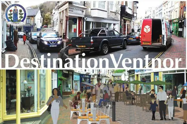
Ventnor Town Council (VTC) have kicked off the much-awaited public consultation to explore the possibility of pedestrianising part of the town centre, with every household in Ventnor this week due to receive a copy of the case for pedestrianisation.

The pamphlet from the VTC opens with a very clear message, that they have not decided, in private or public, to pedestrianise part of the High Street or Esplanade, but wants to work with others to “restore a sense of the Town as a destination, with the High Street as one its attractions”.

Challenges to be faced
The VTC argue that Ventnor’s footfall has fallen in recent years and traders struggle year-on-year with declining visitors.

They believe Ventnor’s High Street is uniquely placed to become a new shopping experience that is “lively, dynamic and exciting, capable of stimulating business development and improving retail performance”.

Range of options
Within the pamphlet (embedded below for your convenience) two possibilities for traffic flow around the town are sketched out.

Click on image to see larger version

Proposal for Ventnor Pedestrianisation map 28 April 2018

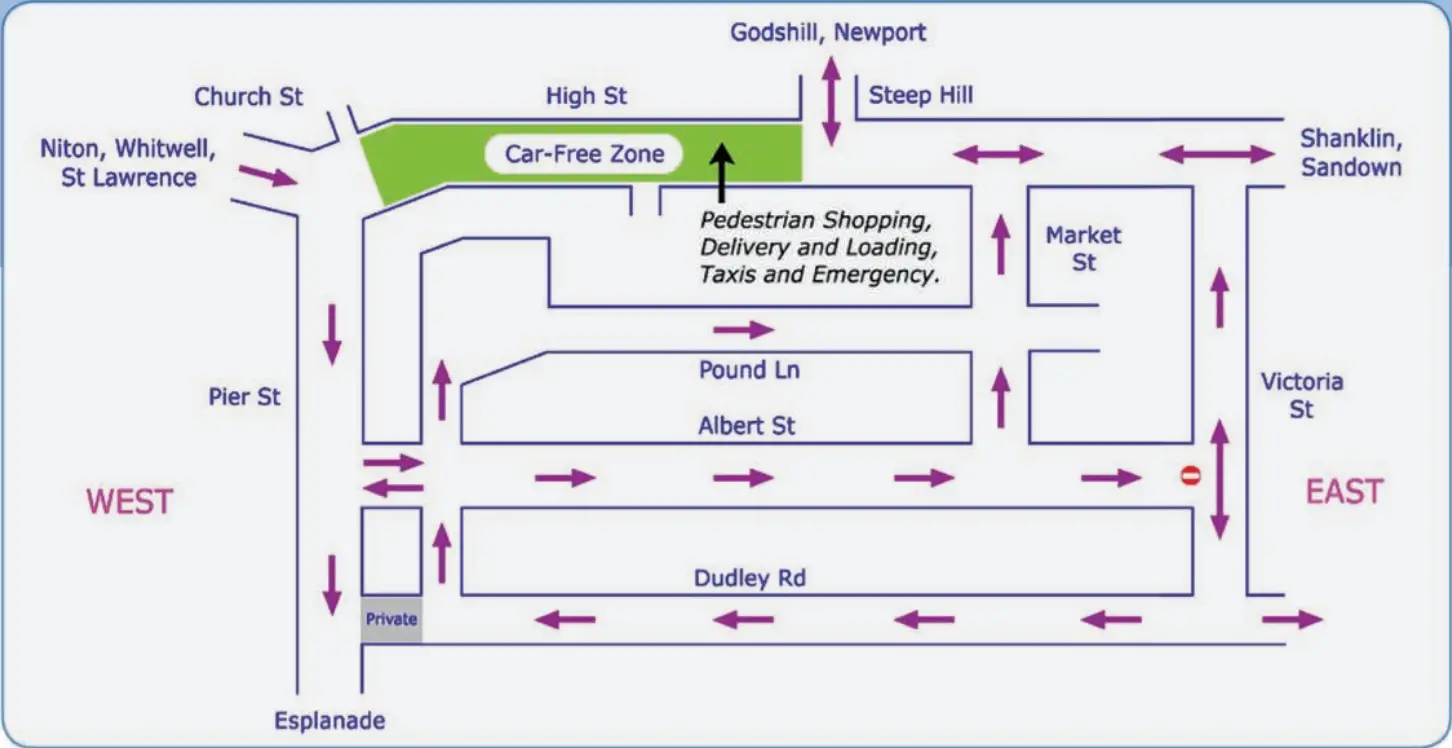
The radical changes could see the direction of traffic on current one-way streets reversed or even changed to two way.

Early opposition
The plans have already attracted opposition from some businesses in the town, with a poster campaign and petition been present for several months.

The consultation process could last up to a year, but in the meantime a number of consultation meetings have been organised for residents and businesses (see final page of pamphlet below).

Click on full screen icon to see larger version


Advertisement
Subscribe
Email updates?
16 Comments
oldest
newest most voted
Inline Feedbacks
View all comments
mariner58
28, April 2018 7:44 pm

At least they’ve left the seafront alone……so far.
I’m not a Ventnor resident but it always had an historical feel and was a nice jaunt to browse the shops and take coffee.
The mere fact that the ‘venerable’ town council wish to consider disrupting it’s existing quaint appeal already excludes it from my itinerary.

steephilljack
28, April 2018 7:59 pm

Probably too late now but is Steep Hill, on the map, what we all know as Spring Hill ? No parking on Albert Street either !

iowdave
29, April 2018 9:32 am

A rubbish idea which will probably lead to the demise of Ventnor shops. Many of the shoppers “stop off” when driving through the town and will not see what is there if High Street is pedestrianised.

Colin
29, April 2018 9:49 am

Looking at the map, where does traffic going towards Niton and St. Lawrence go? Church street is marked as one-way. Have we lost a route out of Ventnor making all the others even busier? Two-way traffic on the upper High Street will be terrible as would two way traffic negotiating the bottom of Spring Hill. How will this improve the quality of life for those living in… Read more »

Colin
Reply to  Colin
29, April 2018 1:31 pm

Further to my earlier comment; if you wanted to go to the Botanic garden or the park or any destination that you currently go up Church Street which leads onto the A3055, Park Road or Undercliffe Drive, you can’t. You would have to go up Spring Hill and Mitchell Avenue, along Ocean View Road and back down Zig Zag or Gills Cliff Roads. How does that make… Read more »

davimel
29, April 2018 10:15 am

Minor point, but an obvious one (to me) and not the last one from me, BUT we rely upon tourism, tourists come in either cars or Coaches and nowhere on this ‘map’ do coaches seem to have access! The ONLY way into Ventnor is via Church street and coaches are supposed to turn left onto Albert St, they cannot turn first left again as it is too… Read more »

electrickery
29, April 2018 11:25 am

The representation of bistro-style street life is disingenuous. Since the High Street must be available to deliveries, emergency vehicles and, of all things, taxis, it will be unusable as a pedestrian area. Credit to Ventnor Council for the initiative, but this one cannot work.

bigj
29, April 2018 1:04 pm

Pedestrianisation / Cafe culture? Ventnor High Street Due to the fact that Ventnor High Street has 4 storey buildings on both sides it remains in the shade during the majority of the day. A light breeze turns it into a wind tunnel on draughty days. The view isn’t too inspiring either. The Esplanade Facing South and with no obstruction from all day sunshine and a constantly changing… Read more »

bigj
Reply to  Sally Perry
29, April 2018 3:14 pm

Certainly not. No problem with your report.
The bias is the VTC approach to BOTH elements of pedestrianisation
All Ventnor High Street, which is a non starter, and nothing relating to the Esplanade, yet.

oldie
Reply to  Sally Perry
29, April 2018 9:10 pm

Of course we know it’s not you Sally who dreamed up this plan. bigj and other business men in the High Street and on the seafront are being remarkably restrained and polite I reckon. They must actually be tearing their hair in quiet despair at the thought of being put out of business by the architects of this idea – as if trade wasn’t bad enough already… Read more »

CB500
29, April 2018 1:33 pm

The pedestrianisation idea is totally ridiculous on it’s own but the map takes it even further into la la land. Did the mayor knock this up at the bar by any chance?

mrincredulous
29, April 2018 2:20 pm

Having scrutinised the maps showm,one must come to one of several conclusions.Either this has been drawn up by someone who has never visited Ventnor,been drawn up after a few to many local ales at one of the fine establishments in the town,or three there are going to be lots of building demolished to make the roads and corners as large as they are going to have to… Read more »

micksey009
29, April 2018 8:15 pm

What a hare-brained scheme and of course it’s totally unworkable. Why does VTC not concentrate its time and scarce resources on the important issues such as providing more essential public lavatories, to quote just one example? Ventnor’s quaint narrow Victorian streets were not built for modern-day traffic. Things just about work as they are but neither of the two traffic options can work in practice unless mega-coaches… Read more »

oldie
29, April 2018 8:51 pm

1. According to the arrows the cars and coach loads of tourists on their Round the Island trips from Sandown and Shanklin direction appear to be being sent straight on to Godshill and Newport and vice versa. Am I correct in deducing that? 2. Apart from expecting tourists to sit drinking coffee in a draughty and sunless lower High Street whilst contemplating the high buildings on both… Read more »

savernake
30, April 2018 8:13 pm

There seems to be a lot wrong with this map and it’s proposed traffic management. If you draw up a map it’s useful to check that you have the right street name…Steep Hill rather than Spring Hill is the most obvious error. I’m finding it difficult to understand whether Victoria Street in Option 1 is to be two way, as the description says, or one way as… Read more »

reCaptcha Error: grecaptcha is not defined