This in from the council, in their own words. Ed
Key routes to Bestival will become busy as tens of thousands of people travel to Robin Hill for this year’s event.
Designated routes
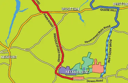
A map has been produced by the council showing the designated routes for Bestival traffic which also outlines areas residents should avoid if possible including the Hare and Hounds junction and Robin Hill roundabout.
The map, as well as other important information about the event, can be found on the council’s website at www.iwight.com.
One-way system for Rowlands Lane
There is an important change for traffic using Rowlands Lane this year, with the road becoming a one-way system.
From 6pm on Wednesday 4 September onwards it will be a one-way direction from the Havenstreet Main Road junction to the Downs Road.
This will remain in place until around 10pm on Sunday evening when the direction will be reversed and traffic flow will be from the Downs Road to the Havenstreet Main Road junction. The road is due to return to a two-way flow from 6pm on Monday 9 September.
Public footpaths and bridleways
There will be restrictions to public footpaths and bridleways close to the Bestival site during the event, and a 30mph speed limit will also be in force on roads leading to and outside the site for safety reasons.
To help with traffic arriving or leaving by the Red Funnel car ferry in East Cowes on Monday 9 September, Beatrice Avenue will be no waiting at any time and will also become a one-way system from 5am until midnight to help reduce congestion.
In Binstead, from 5am on Thursday 5 September until 10pm on Monday 9 September, ‘no waiting at any time’ zones will be in force on Newnham Road.
Car parks
Council run car parks at Yaverland seafront, Fort Street in Sandown, North Walk and Appley Park in Ryde will be closed and held in reserve each day to be used as vehicle holding areas should the Bestival site become inaccessible for cars.
River Road car park in Yarmouth will also be partially closed. Should they not be required, these car parks will be re-opened to the public at some point each day.
Keeping traffic moving
The council, along with key partners including Island Roads, ferry operators, Hampshire Police as well as voluntary sector organisations will again have officers stationed at points on the key routes to help keep traffic moving.
Motorists are also being advised that to assist in the free flow of traffic along key routes, vehicles illegally parked on roads designated and signed as ‘clearways’ will be towed away.
Implementing a robust traffic management plan
John Metcalfe, Isle of Wight Council deputy director for economy and environment said:
“Using our experience of recent events we will implementing measures that are designed to keep the Island’s traffic flowing throughout the period of the Bestival
“Again we are working with key partner agencies to implement a robust traffic management plan to minimise disruption for motorists and residents to ensure everyone has a great time.”
Q and A session on Facebook
The council has also organised a live question and answer session on its Facebook page where residents can ask partner agencies about the event and changes to services.
The event, which takes place between 6pm to 7pm on Monday 2 September, will involve officers from the council, Island Roads, the Bestival itself and Hampshire Police answering questions live. For details on how to take part in the q and a session, people should log on to www.facebook.com/isleofwightcouncil and ‘Like’ the page.
Map © Isle of Wight Council