
The Isle of Wight council share the latest traffic plan details for next week’s Isle of Wight Festival. Ed
It’s almost time for the Isle of Wight Festival to begin and The Isle of Wight Council, Island Roads and Hampshire Constabulary are once again working closely with the organisers of this year’s festival to ensure traffic flows smoothly and disruption is kept to a minimum as thousands of music lovers head to the Island for the world-famous event.
The council and partner agencies have approved the traffic management plans submitted by the event organisers, covering areas such as event car parks, separating Red Funnel and Wightlink traffic and measures to ensure close co-ordination between partners.
Keeping disruption to local traffic a minimum
The plan is designed to ensure disruption to local traffic is kept to a minimum, although some delays are inevitable with the increased levels of traffic on the roads.
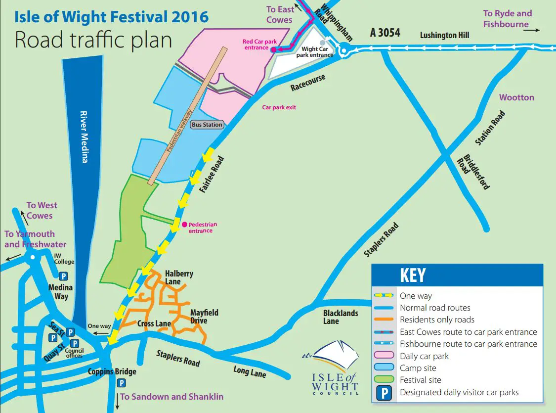
The main route for festival traffic from the Red Funnel terminal at East Cowes will be up York Avenue and along Whippingham Road where it will turn right onto East Cowes Road and into the red festival car park. As a contingency, if there are any substantial hold ups on the Whippingham Road, festival traffic will be turned left onto Alverstone Road, where it can be temporarily ‘stacked’ and released into the network when the roads to the festival site are less busy.
Festival-bound vehicles travelling from the Wightlink terminal at Fishbourne will be directed to the right on to Kite Hill, through Wootton, down Lushington Hill and right at the Racecourse roundabout and then left into the appropriate festival car park.
If car park entrances are blocked
If any of the entrances to the car parks are temporarily blocked, or an incident occurs on any of the roads being used by festival traffic, there are a number of options that can be considered by the event organisers; the council also has arrangements in place to divert traffic around the highways network if necessary.
Island Roads will be keeping residents up to date with routine traffic information and details of road closures and diversions, while the council will provide updates about those council services affected by the festival. Hampshire Constabulary will provide security and safety updates. Messages will be shared via social media and local media.
One way system on Fairlee Road
The council would like to remind people that the one way system along Fairlee Road, Newport will be put in place from lunchtime on Wednesday 8 June. All outbound traffic from Newport will be directed up Staplers Road. Full details can be found on the council’s website.
Councillor Shirley Smart, executive member for public transport, tourism, recreation and heritage, said:
“The council has been working closely with the event organisers and our partner organisations to once again ensure that this year’s festival will be a successful and enjoyable event. My thanks go to the all involved in making sure the event runs smoothly, with the minimum amount of disruption to residents and to the army of volunteers who will help throughout the event.
“It’s important to stress that for the duration of the festival, Newport will be open for business as usual, and I would strongly encourage members of the public to continue to support local shops and other businesses during the event, as they have done in previous years.”
Click on the image for full screen version
Download the map to print at home or work.
Stay up to date with changes
Residents meanwhile are encouraged to look at the dedicated festival pages on iwight.com, which contain important information about the road closures and diversions, including access to Seaclose Park and changes to council services, as information becomes available.
The council asks that residents plan their routes to avoid the designated festival traffic routes on the Wednesday, Thursday, Friday and Monday of the event – when traffic volumes will be their highest.
Maps, festival related and travel information can be found on the council’s Website.
Image: © Mike Hughes