This in from the Isle of Wight council, in their own words. Ed
The Isle of Wight Council, Island Roads and Hampshire Constabulary are working with the organisers of this year’s Isle of Wight Festival to help ensure traffic flows smoothly and disruption is kept to a minimum as tens of thousands of people head to the Island for the world-famous music event.
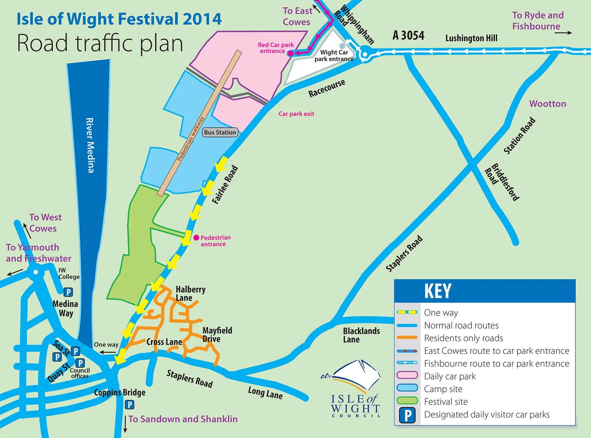
Traffic management plans approved
Traffic management plans have been submitted by the event organisers and approved by the Isle of Wight Council, in consultation with partner agencies.
With improvements made by festival organisers to event car parks, separation of Red Funnel and Wightlink traffic and close co-ordination between partners – which worked well last year – disruption to local traffic should be kept to a minimum, although some delays are inevitable with the amount of extra traffic on the roads.
Main routes from ferry terminals
The main route for festival traffic from the Red Funnel terminal at East Cowes will be up York Avenue and along Whippingham Road where it will turn right onto East Cowes Road and into the red festival car park.
As a contingency, if there are any substantial hold ups on the Whippingham Road, plans have been developed and agreed to turn festival traffic left onto Alverstone Road, where it can be temporarily ‘stacked’ and released into the network when the roads to the festival site are less busy.
Vehicles travelling from the Wightlink terminal at Fishbourne will be directed right on to Kite Hill, through Wootton, up Lushington Hill and right at the Racecourse roundabout and the left into the Wight festival car park.
Should any of the entrances to the car parks be temporarily blocked, or an incident occur on any of the roads being used by festival traffic there are a number of alternative options that can be considered by the event organisers; additionally the council has arranged alternative parking facilities so that traffic can be diverted off the network if required.
Keeping residents updated
Island Roads will be keeping residents up to date with routine traffic information and details of road closures and diversions, while the Isle of Wight Council will provide updates about council services affected by the festival and Hampshire Constabulary will provide security and safety updates. Messages will be shared via social media and local media.
The council would like to remind people that the one way system along Fairlee Road will be put in place from lunchtime on Wednesday 11 June, people are advised to plan their journeys accordingly.
Smart: “Hoping for a sunny weekend
Councillor Shirley Smart, Executive member for economy and tourism, said:
“The council has been working closely with the event organisers and its partners to ensure another successful festival. We are all keeping a close eye on the weather and hoping for a sunny weekend for the thousands of Island visitors and residents who will be attending the event.”
More info
Residents are encouraged to look at the dedicated festival pages on iwight.com which contain a wealth of important information about road closures and diversions, access to Seaclose Park and changes to council services.
The council asks that residents plan their routes to avoid the designated festival traffic routes on the Wednesday, Thursday, Friday and Monday of the event when traffic volumes are at their highest.
Click on image to see larger version