The Environment Agency have issued several flood alerts for the Isle of Wight today (Tuesday).
The Met Office have issued a yellow ‘Be Alert’ weather warning for rain until 6pm today.
Gurnard Luck
At 9.45am the EA issued a Flood alert for Gurnard Luck:
High river levels on Tuesday may lead to flooding.
Flooding is possible on 03 February 2026 , as further rain is forecast (up to 20mm).
Flooding could affect gardens or properties nearest to the river in Marsh Road. River levels are expected to rise again, as up to 20mm of rain is forecast today 03/02/2026. Rainfall is forecast to continue until 21:00 03/02/2026. River levels will increase at each high tide, as the incoming tide will prevent the river from flowing out to sea. Tide times are 03/02/2026 11:45 and 04/02/2026 00:15. There is potential for further rainfall Thursday and Friday, if this is realised the river will respond again.
We are monitoring rainfall and river levels and will ensure the river is kept free of reported blockages.
Avoid low lying roads near rivers, which may be flooded . Including Marsh Road, Gurnard.
You can stay up to date with the flood alert on the EA website.
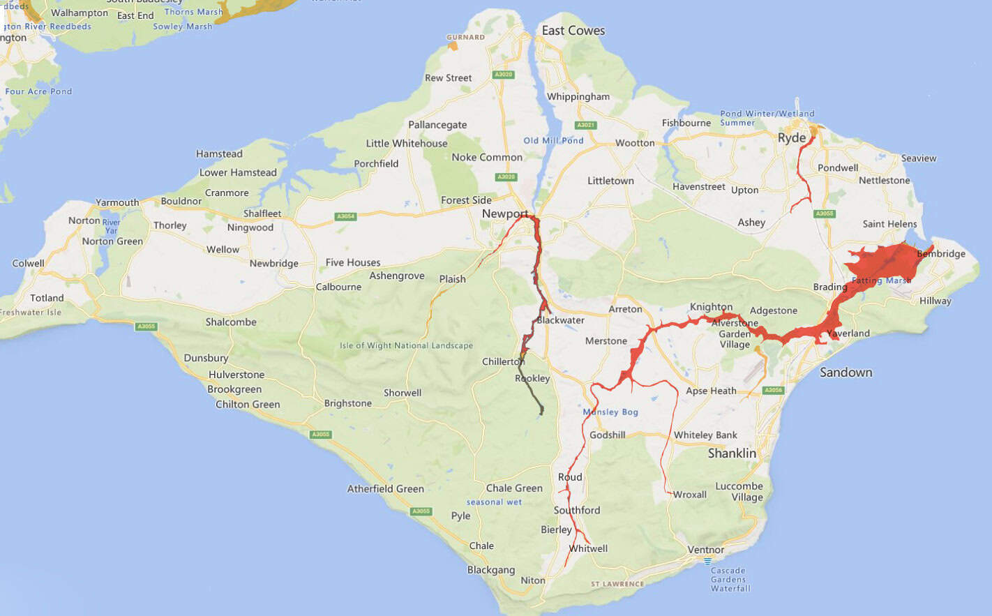
River Medina
At 9.53am the EA issued a Flood alert for River Medina:
High river levels on Tuesday may lead to flooding.
Flooding is possible on 03 February 2026 , as further rain is forecast (up to 20mm).
Flooding could affect land, gardens, and possibly roads at Blackwater, especially at Blackwater Hollow on the A3020 near the Mill Farm and at Sandy Lane. River levels are expected to rise again, due to the rainfall (20mm) forecast for today 03/02/2026. This may result in river becoming very high at St George’s Way, Shide. Rainfall is forecast to continue until 21:00 today, 03/02/2026, before clearing the area. There is potential for further rainfall on Thursday and Friday, if this is realised the river will respond again.
We are monitoring rainfall and river levels and will ensure the river is kept free of reported blockages.
Consider activating any flood protection products you may have . Avoid flooded ground, flood water could be deep.
You can stay up to date with the flood alert on the EA website.
Lukely Brook
At 9.58am the EA issued a Flood alert for Lukely Brook:
High river levels on Tuesday may lead to flooding.
Flooding is possible on 03 February 2026 , as further rain is forecast (up to 20mm).
River levels are expected to rise again, due to the rain (20mm) forecast for today 03/02/2026. Flooding could affect property at the bottom of Castle Street. The Aquatics Centre at Vicarage Walk near Foxes Road may also flood. Water levels may be very high at Caesars Road and Old Westminster Lane, and the river could come out of bank flooding roads and parked cars. Rainfall is forecast to continue until 21:00 tonight, 03/02/2026, before clearing the area. There is potential for further rainfall Thursday and Friday, if this is realised the river will respond again.
We are monitoring rainfall and river levels and will ensure the river is kept free of reported blockages.
Consider activating any flood protection products you may have . Particularly properties next to the river at Vicarage Walk.
You can stay up to date with the flood alert on the EA website.
Eastern Yar
A Flood Alert for the Eastern Yar was updated at 10.41am:
High river levels on Tuesday may lead to flooding.
Flooding is possible on 03 February 2026 , as heavy rain (16mm) fell on 03/02/2026.
River levels are expected to rise throughout today (03/02/2026) as further rainfall (up to 15mm) is forecast. It is possible that flooding may affect a small number of properties at Alverstone and Langbridge this afternoon (03/02/2026).
Flooding will impacts gardens at Whitwell High street, Moreton Common Road and Golf Links Road, Fort Holiday Park, Sandown Sewerage Treatment Words and may affect gardens and property at Nicholas Close, Brading. Further rain is forecast on Thursday (05/02/2026) and Friday (06/02/2026). This will likely cause the river to respond again.
We are checking rivers for blockages and operating Bembridge sluices.
Consider activating any flood protection products you may have . Including in Alverstone.
You can stay up to date with the flood alert on the EA website.
St Johns, Ryde
At 10.50am, the EA issued a Flood alert for St Johns, Ryde:
High river levels on Tuesday may lead to flooding.
Flooding is possible on 03 February 2026 , as 10mm of rain has fallen this morning.
This is a modest amount of rainfall but follows recent wet weather. River levels are expected to continue to rise, as a further 10mm of rain is forecast for the remainder of today 03/02/2026.
Flooding could affect the railway tracks, upstream of St Johns Station. Flooding of the stations buildings or property is currently not expected.
Rainfall is forecast to continue until 21:00 tonight, 03/02/2026. There is potential for further rainfall on Thursday and Friday, if this is realised the river will respond again.
We are closely monitoring the situation and keeping the Monktonmead Brook clear of blockages.
Consider activating any flood protection products you may have . Move vehicles from depots next to the railway line and river.
You can stay up to date with the flood alert on the EA website.
Road closures
A number of roads remain closed following flash floods on Sunday night. Check the one.network website for live updates.
See Southern Vectis website for any service updates.
Article edit
10.53am 3rd Feb 2026 – Updates added for Eastern Yar and St John’s, Ryde