Back in December 2013 (18th), Isle of Wight MP, Andrew Turner, issued a press release declaring that extra Government funding could be heading to the Island after the Isle of Wight had been included in a draft map for Assisted Area Status.
In the press release, which was duplicated on the Isle of Wight council’s website, leader of the Isle of Wight Council, Ian Stephens, said,
“We are delighted that the Isle of Wight has been included in the Government’s initial report.”
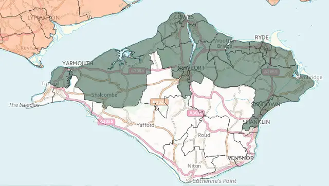
In our follow-up article, where EU expert Cllr Harry Rees told us the status could prove pointless unless under the correct classification, it was also revealed that only certain parts of the Island had been included in the draft map.
Why not the entire Island?
We had asked the Isle of Wight council why only parts of the Island were included in the draft map. They told us that all wards on the Isle of Wight had been included in the submission sent to government, so we should ask them.
We did just that, a spokesperson from the Department for Business, Skills and Innovation told us,
“The proposed Map already includes the majority of businesses on the Isle of Wight that could benefit from the investment of regional aid. Many of these businesses employ workers from across the Isle of Wight.
“If the Isle of Wight council wants to make the case for including further wards, this consultation provides the opportunity to do so. “
IWC must make a very strong case for inclusion
However, it looks as though it may not be as straight-forward as it sounds. The government spokesperson went on to add,
“Demand for inclusion on the draft 2014-2020 Assisted Areas Map is well in excess of the amount of population coverage that the UK Government has to allocate under European Commission rules.
“Wards will therefore only be included where a very strong case has been made, based on all the principles set out in the consultation.”
What action will the council take?
We asked the council “What steps are being made for IWC to make a case for the other wards to be included?”
They replied,
“We will be responding to the consultation draft with the Solent LEP and will be seeking backing from local businesses to support our response.”
Given Cllr Rees’ comments on the subject of classification, we also asked whether the council planned to make a case for the classification to be changed from Criteria 1 to Criteria 3 (an Island).
They replied,
“The council would prefer the whole Island is designated an assisted area. It is currently considering the options available to achieve this and will make a decision in due course.”
When did officers find out about draft map?
We (and OnTheWight readers) thought it was surprising that the press release from the MP and comment from the leader of the council made no mention that only parts of the Island had been included.
We got in touch with the council to find out how this omission could have been made. A spokesperson for the Isle of Wight council told OnTheWight,
“Officers became aware in the days after the press release was issued by the MPs office in December.”
Discrepancy in facts
Unfortunately this doesn’t match what OnTheWight had been told by civil servants within the Department for Business, Skills and Innovation.
They told OnTheWight,
“This stage of consultation commenced on December 18th when the Map was published and the Isle of Wight Council was made aware of it.”
The council has until 7th February to make their case for inclusion of all wards on the Isle of Wight. We’ll let you know once we hear more.